Satellite to forecast Olympic weather
(Xinhua)Updated: 2006-12-08 14:15
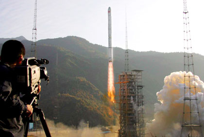 A Long March-3A carrier rocket, with Fengyun-2D meteorological satellite, blasts off from Xichang, Sichuan Province December 8, 2006. [Xinhua]  |
China successfully launched its second geostationary orbit meteorological satellite, Fengyun-2D (FY-2D), on Friday to provide better weather forecast services for the Beijing 2008 Olympic Games.
The FY-2D satellite was launched into the target orbit at 8:53 am aboard a Long March-3A carrier rocket from the Xichang Satellite Launch Center in southwest China's Sichuan Province.
"The satellite will monitor weather changes at all the Beijing 2008 Olympic Games venues," Li Qin, chief designer of the FY-2D, said.
"The FY-2D will provide accurate and timely information about weather changes to help us with weather forecasts during the Beijing 2008 Olympic Games, especially the opening and closing ceremonies and important contests," he said.
The satellite separated from the rocket about 24 minutes after lift-off and then successfully entered the geosynchronous transfer orbit, according to the satellite monitoring center in Xi'an.
This launch is the 11th flight of the LM-3A carrier rocket and all 11 flights have been successful.
"The LM-3A has entered a phase of steady commercial operation," said Li Jinghong, deputy designer of the rocket.
China started developing the LM-3A in March 1986. At its first launch on February 8, 1994, the LM-3A carrier rocket successfully sent the Shijian-4 satellite and a dummy satellite into orbit.
The 52.52-meter-long LM-3A is mainly used to launch satellites into geosynchronous transfer orbit. With a payload of 2.6 tons, it can transport several satellites at the same time.
"We are continuing to improve the technology and add equipment. For the launch of the FY-2D we added a 48-channel global positioning system," Li said.
The 1.39-ton FY-2D satellite will take up a position in the next few days at 86.5 degrees east longitude right above the equator.
The FY-2D, developed and manufactured by the Shanghai Academy of Spaceflight Technology affiliated to China Aerospace Science and Industry Corp., can observe weather changes around the clock. It is capable of carrying out infrared nephanalysis of the form and structure of clouds and can also analyse data about daytime light.
The Fengyun-2D will form a twin-star observation system with Fengyun-2C, China's first geostationary orbit weather satellite which went into orbit on October 19, 2004, according to the China Meteorological Administration (CMA).
The two satellites have their own observation tasks, but can also replace each other if one of them malfunctions, the CMA said.
FY-2D will help the CMA bolster weather monitoring information from western China where cold fronts and sandstorms usually begin.
"The Fengyun-2D will expand our geostationary weather observation range and improve the forecast and monitoring of disaster weather," said Yang Jun, director of the National Satellite Meteorological Center.
Its ground control system, which experts describe as the most advanced in the world, will help monitor the space environment and satellite movement.
The system will also work around-the-clock with the satellite in orbit to receive images every half an hour.
It will figure out sea surface temperatures and parameters of clouds and airflows after further processing the data and images sent back by the satellite, keep the statistics on file and provide application services.
|
||
|
||
|
|