Interactive digital map helps bring historic events to life
By Zhou Wenting ( (China Daily)
Updated: 2011-06-26 17:12
BEIJING - A digital map marking where important historic events for the Communist Party of China (CPC) took place has been published online.
"This is the first three-dimensional dynamic map demonstrating the process of major historic events of the CPC. The 'red map' is a review of the glorious history of the CPC from a new perspective," said Xu Deming, director of the National Administration of Surveying, Mapping and Geoinformation.
Internet users can visit hsdt.sasmac.cn to browse the map, although it is necessary to download a small program to use the interactive features.
Visitors can see historic figures, sites of major events, high-quality red tourist routes, bases for patriotism education, and significant battles in a visual, spatial and dynamic way.
Tang Xinming, deputy director of the Satellite Application Center of Surveying and Mapping of the administration, said historic figures in the system include revolutionaries of the older generation and heroic models among generalissimos, generals and those who made substantial contributions to the founding of the People's Republic of China.
Tang said that in the part covering "major events", visitors can review influential incidents with animated scenes. He cited the example of the online-retake of the Long March, which refers to the strategic transfer of the Chinese Workers' and Peasants' Red Army (1928-1937) from 1934 to 1936, covering a distance of 12,500 kilometers.
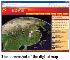
"We give an account of the long journey in the form of a dynamic map, and highlight key spots on the path to mark battles and major events, which is a record of the routes of the daily march
?of the Red Army," Tang said.
He said all the information on the digital map comes from history.
"We can understand the difficulties and obstacles of the Party and the long-range routes they walked in the old days before they founded New China," He said.
The red map is also an extension of the history of Chinese revolutions. "The map combines Party history with dynamic geographic information. The static and dynamic information on the dynamic map display the glorious history of revolutions," Tang said.
A total of 30 provinces, autonomous regions and municipalities have also worked out more than 100 local paper red maps.
The red map of East China's Jiangxi province, which is crowned "the cradle of Chinese revolutions", highlights 160 red scenic spots in the cities of Anyuan, Nanchang, Ruijin and Jinggangshan, which were respectively the cradles of the Chinese workers' movement, Chinese military, the first Chinese communist regime and Chinese revolutions.
The first shot of the armed struggle against the Kuomintang was fired in the Nanchang Uprising on Aug 1, 1927, which marked the beginning of the independent leadership of the CPC in revolutionary wars and establishing the revolution.
Nanchang is where the flag of the Chinese Red Army was first raised, and Aug 1 became the Army Day.
The red map of Shanghai is tailored for middle and primary school students. A total of 246 bases for patriotism education from State-level to district-level are marked on the map. The introduction of each base as well as addresses, opening hours and surrounding traffic information are also printed on the map.

Top News
Xi emphasizes adherence to CPC Congress spirit
Top legislator urges implementation of congress spirit
Moderately prosperous China brings chances to world
Video